
It’s never been easier to enable indoor mapping, wayfinding and location tracking. Using Esri’s ArcGIS Indoors platform, you can now create a smart indoor environment by geoenabling your visitors, assets and workers in the built environment.
IoT Indoors
Ever since the first days of low cost car GPS technology and smart phones, our world has become increasingly mapped and routable. It has never been easier to get from A to B, whether that location be an address, placename or public transit route. The amount of mapping and routing technologies available these days is truly staggering. What more could we need? Actually, a lot when it comes to mapping and navigating the indoor/built environment, where people spend 90% of their time. The built environment is rapidly expanding worldwide and an increasingly larger proportion of people live in urban areas. Adding to this, 2 out of 3 buildings in the US currently do not have a common operating picture of space and asset utilization. As a result, navigating, optimizing and understanding where things are located in the built environment has become increasingly important. When it comes to navigating indoor spaces, most are still reliant on older 2D floorplans and paper. Contrast that with outdoors technology, where we can easily navigate with ease using any device. However, the same problems that were solved with these technologies outdoors (navigating, routing, finding optimizing and understanding assets usage) apply to the indoor environment as well. With these needs, a number of solutions are beginning to take shape…Enter Esri ArcGIS Indoors.
Source: Esri
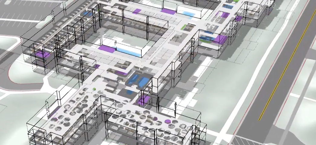
ArcGIS Indoors is Esri’s flagship solution suite for bringing the indoor world to life, seamlessly integrating CAD diagrams, BIM data, 3D models and indoor positioning systems into an optimized set of solutions and apps for indoors geolocation. ArcGIS Indoors easily integrates with the ArcGIS platform to power all manner of indoor geolocation applications.
What can be done with ArcGIS Indoors?
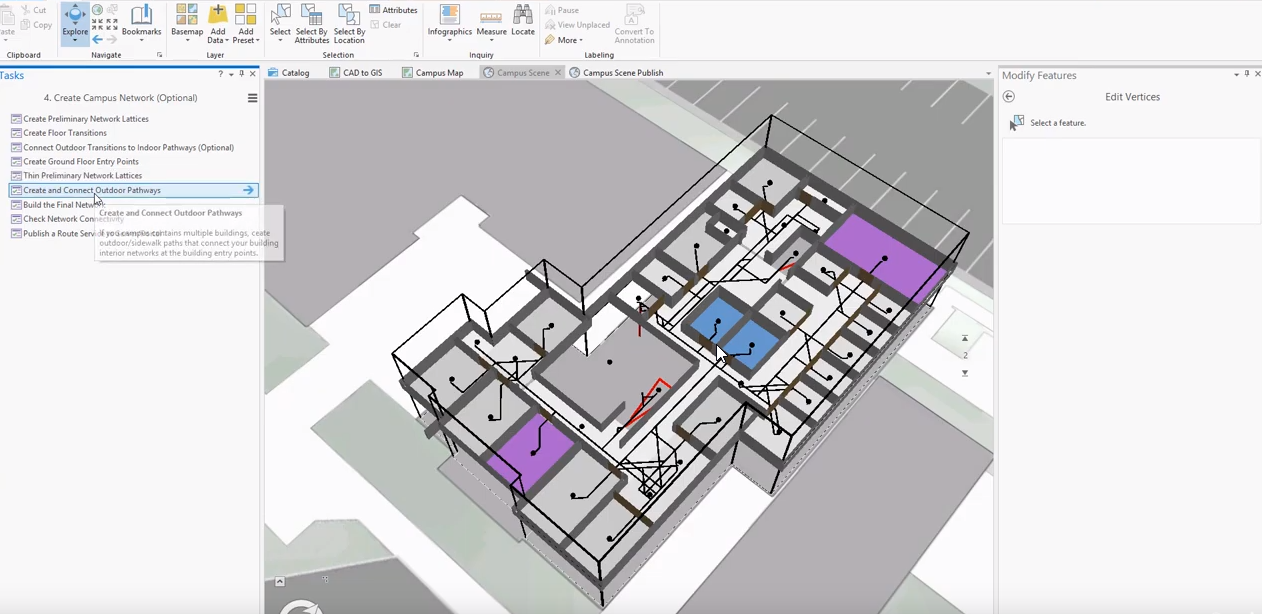
ArcGIS Indoors is a solution suite: a set of extensions, tools, templates and apps that can help solve the various problems encountered in indoor geolocation. With Indoors, you can build a geodatabase information model from existing BIM and CAD floor plans, develop an indoor (and outdoor) seamless routable network that is floor aware, allow for indoor wayfinding using web and native (Android,iOS) applications, and track user / asset locations accurately in real time.
Source: Esri
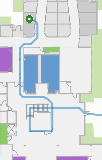
Perhaps the most obvious example is just simply getting around. How does one route through an indoor space? How does a new visitor to a public space, building or campus quickly understand their surroundings and where they need to go? Routing and wayfinding using ArcGIS Indoors can quickly allow users to visualize their route and receive turn by turn directions to their destination. Less time wasted, better visitor experience and better operational efficiency for employees.
Source: Esri
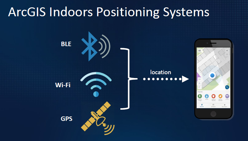
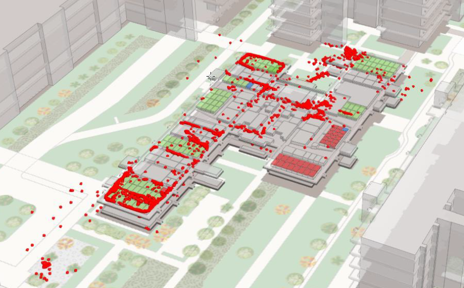
Once the your model has been built and your indoor routable network is in place the next challenge is to accurately locate yourself in this environment. The linchpin in any routing solution relies on accurate location of the user in near real time. GPS is not reliable or completely unavailable in the built environment. Likewise, many solutions for accurate indoor geolocation involve custom and proprietary software/hardware that is costly and complicated to setup. This is where ArcGIS Indoors really shines. To that end, Esri has teamed up with the best in the business and begun to build an indoor positioning solution that is system agnostic (meaning you can utilize your own third party Wifi or bluetooth beacons). ArcGIS Indoors brings the capability to accurately map and locate using these existing systems after a simple and streamlined setup process. Once setup, ArcGIS Indoors maps and apps can easily locate users and assets accurately across rooms, hallways and floor transitions.
Source: Esri
Asset management is another key feature of ArcGIS Indoors. As mentioned earlier, a majority of buildings and campuses do not have a common operating picture. Locating assets quickly and providing a common real-time picture of your assets in your building can save a substantial amount of time and money, in terms of operational efficiency. Employees, contractors and visitors can be quickly and accurately routed to the resources they need. They could also view the locations and status of these assets in real time.
Source: Esri
Once you have your indoor spaces well mapped, your indoor positioning system deployed, and your assets and items tracked in this environment, the next question one can ask is one of utilization: how much or how well are our assets being utilized? Using current and historical data on asset locations and movements captured using ArcGIS Indoors, you can begin to optimize space management and asset allocation. Bottom line, this can save a substantial amount of money in terms of space savings and maximizing asset utilization efficiency.
How to get started
If your a developer or GIS specialist, there are a number of resources you have at your disposal to better understand Esri’s indoor solutions. Depending on your needs (information kiosk, peer to peer location app, asset optimization and utilization), there are a number of examples to get you started.
Our Esri specialists at DVG have had the pleasure of visiting and training with the ArcGIS Indoors team to acquire a thorough understanding of the ArcGIS Indoors information model and platform. We can help you architect and deploy an ArcGIS Indoors enabled solution, indoor positioning system or application. From data gathering and preparation to authoring maps and services or developing/ integrating with custom applications, we have the expertise to provide support throughout the entire project lifecycle.
For more information contact our team at info@dvginteractive.com