
Streamlined Transportation Planning
Long Beach Transit is responsible for providing bus and shuttle services within the city of Long Beach, CA and adjacent areas, with a focus on meeting the transportation needs of all members of the community. The planning process is integral to providing effective transportation solutions. DVG built a service planning dashboard with integrated maps and document automation to streamline the process for a more informed and efficient planning process.
Assignment
Long Beach Transit (LBT) is responsible for providing bus and shuttle services within the city of Long Beach, CA and adjacent areas, with a focus on meeting the transportation needs of all members of the community. LBT provides public transportation to more than 23 million annual boarding customers in southeastern Los Angeles County and northwestern Orange County. With a service area covering over 100 square miles across 14 cities, LBT annually runs more than 6.9 million service miles over 700,000 service hours, using 250 fixed-route buses. To support this mission, LBT must create transportation plans in an efficient and impactful way. To assist LBT, DVG was tasked with creating a Transporation Service Planning Dashboard as a source of up-to-date information and a planning collaboration space that leverages existing technology investments in Microsoft and Esri.
Approach
The goal of this project was to create a Service Planning Dashboard that incorporated up-to-date GIS transportation data and maps along with the related planning documents that are crucial for coordination and decision making. To accomplish this DVG’s approach was to build a SharePoint site with ArcGIS Enterprise integrated to enable stakeholders to view accurate GIS data that has “geotagged” planning documents. Additionally, DVG build a business process automation workflow using Microsoft Power Automate that tracks the status of planning documents, notifies appropriate stakeholders, and ensures that relevant documents are seen by the right people at the right time. This wholistic and integrative approach meant that transportation planning is managed in transparent, accountable, and streamlined way. This approach ensures LBT is realizing the value of their technology investments to meet their goals, which ultimately benefits the citizens of Long Beach.
Results
The project resulted in a solution comprised of several deliverables, each helping to streamline the LBT Transportation Planning process:
- A Microsoft 365 Gov SharePoint Dashboard site with tailored branding to meet the design standards of LBT.
- ArcGIS Enterprise integration for up-to-date maps and spatial dashboards.
- Map-based interfaces where spatial data are linked, or “geotagged”, to planning documents.
- Power Automate workflows for managing and tracking the planning document lifecycle.
- An integrative and flexible solution that was built rapidly, is secure, and can be maintained with little effort in the long run.
Solution Architecture
DVG was able to save the client time, money, and training effort by leveraging existing software that LBT is already familiar with. Specifically, The Service Planning Dashboard was implemented within the LBT Microsoft 365 for Government environment using COTS configurable components such as SharePoint and Power Automate. The SharePoint site was integrated with an internal ArcGIS Enterprise site in order to leverage maps, apps, and geotagged documents. This solution architecture was cost effective, simple, and was deployed rapidly.
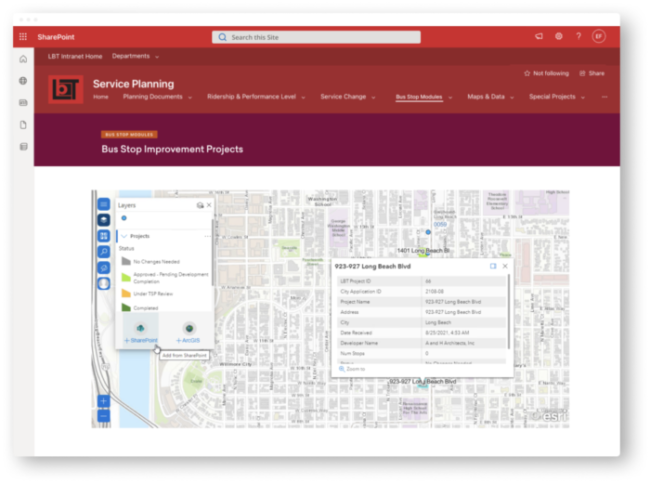
Planning Areas Map & Document Geotagging
The GIS team owns and maintains the latest transportation data including development areas, bus stop locations, and street development locations. DVG integrated these data directly into the Planning Dashboard so that all stakeholders are viewing the up-to-date and authoritative data. Furthermore, DVG enabled ArcGIS for SharePoint to that planning documents can be geotagged to spatial features such as points, lines, and polygons.
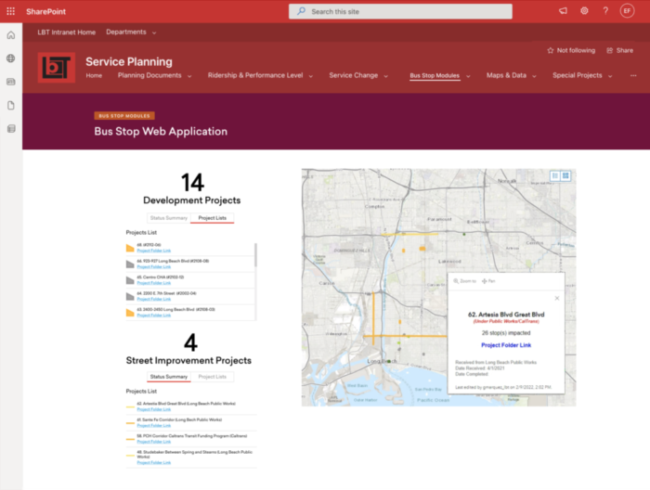
Planning Geospatial Dashboard with Linked Documents
A geospatial dashboard that includes summary statistics, key performance indicators, and active projects was also included in the SharePoint site. Furthermore, the map features that are included in the dashboard are linked to SharePoint directories that include relevant documents for each particular planning area or feature. This type of visualization creates a positive user experience by presenting tailored information that is most relevant to the users which saves time and avoids confusion.
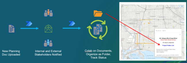
Planning Document Workflow Automation
It can take day, weeks, or months to fully plan and approve a transportation project. The process involves many stakeholders, documents, meetings, and much coordination. To streamline the process, DVG built Power Automate workflows that track the revisions, approval status, and relevant stakeholders for documents that are related to each project. Stakeholders are informed via email when there are certain status changes or actions that must be taken on the document. This workflow automation saves LBT much time and effort by creating a structured document organization, process, and notification system.
Powered by Esri & Microsoft
As proud partner of Esri and Microsoft DVG integrated the powerful capabilities of both platforms into this application with great success for the customer.