

Last week DVG was in southern California to participate in the Esri Partner Conference and Esri Developer Summit 2023, and we couldn’t be more excited for the road ahead in 2023 and beyond! Over the course of the week we gained valuable insights through direct communication with the many product teams that build all of the great tools at Esri. Though the Esri Developer Summit is one of the company’s lesser known events, it has much more to offer the general GIS user than meets the eye. This year’s Summit did not fall short of leaving a lasting impression. Here are just a few of the many updates that we were able to take in from the last week and that you may not be aware of until after the general User Conference.
General Service Offerings
Esri has been busy over the last year adding new service offerings to their core services. In April, Esri will release a brand new Places service (POI layer) that will incorporate over 50 million points of interest that are continually updated from around the world. The places service will allow you to filter and view specific points based on preset categories such as for site selection, economic development and market analysis. In addition, Esri will be releasing some new basemap offerings this spring including new basemaps (a new Outdoor basemap and OSM blueprint basemap) and a basemap styles API. The basemap styles API offers parameters to dynamically style the basemaps, such as for theming and content filtering. The most impactful may be its new language parameter that will allow you to add localization to the map’s presentation.

ArcGIS Online
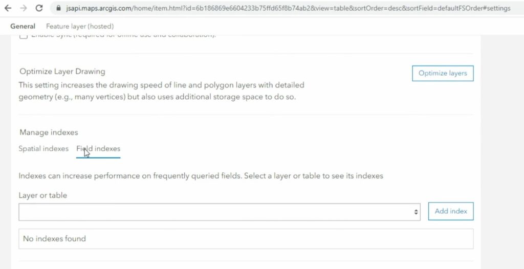
Esri continues to bring exciting features and improvements to its ArcGIS Online platform. One such feature we are thrilled about (albeit being less flashy) is the ability to create full-text indexes on hosted feature and table fields. This allows for a rich partial text auto suggestions and improved search capabilities against your hosted data.
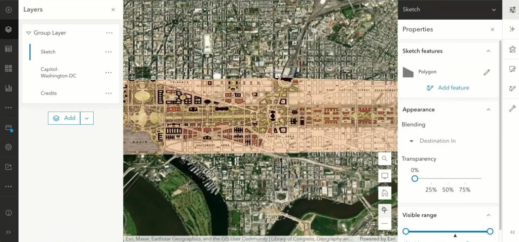
Another exciting feature that is coming to the online Map Viewer is the ability to dynamically add and style Media Layers (coming soon!). Media layers are a recent addition to the online Map Viewer and Javascript SDK that allows users to quickly overlay and lightly georeference scanned maps, images and video to your existing webmap. These media can easily be overlaid in the webmap and blended into the map via core styling options such as blending, transparency and bloom.
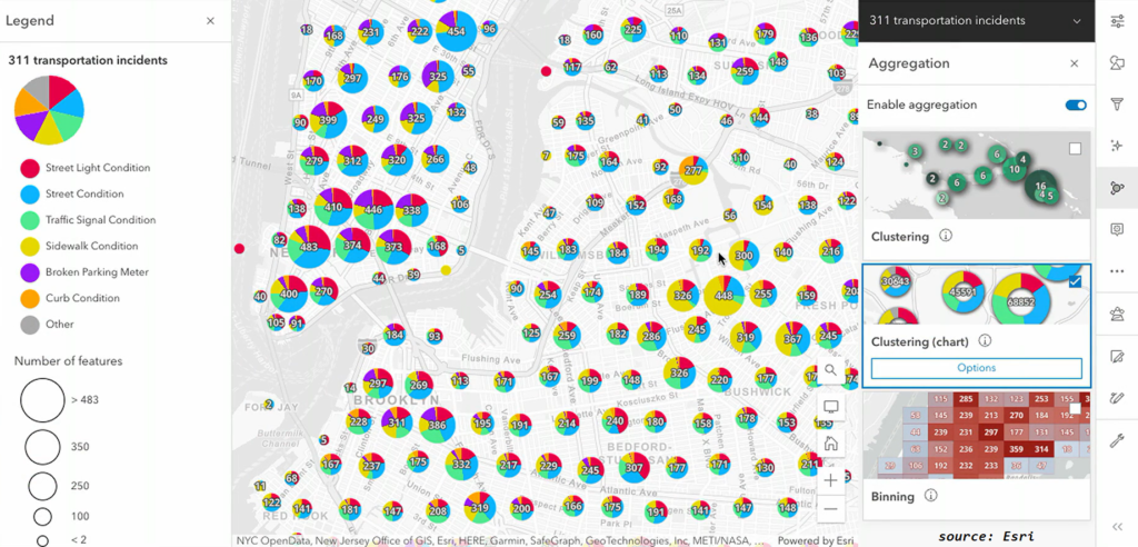
Another enhancement to the Map Viewer is the addition of new aggregation styling options that have also recently been added to the ArcGIS Javascript SDK, such as cluster charting and binning. Finally, Esri has continued to improve on the analysis capabilities in the web Map Viewer by offering additional analysis tools directly in the interface, with a plan for publishing more of these core geoprocessing tools as web components in years ahead.
ArcGIS Enterprise
There were a number of updates and announcements at this year’s Summit that pertained to ArcGIS Enterprise. The upcoming 11.1 release of Enterprise this spring will include a set of new features, including:
- Custom Data Feeds
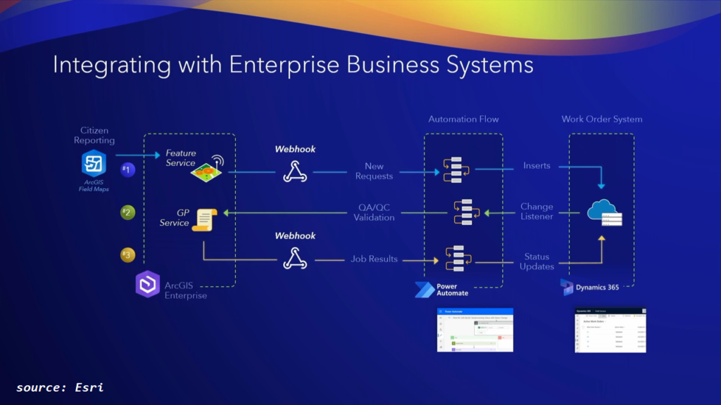
Custom data feeds will allow users to expose their data as an input to create read-only feature services. Potential input data includes formats not natively supported by ArcGIS clients, without even needing to register it with ArcGIS Enterprise. - Webhooks for Feature Services and Geoprocessing Services
In addition to the existing webhooks in AGE, such as for content, users and groups, you will now have the ability to publish webhooks that are triggered on feature service and geoprocessing events, providing the opportunity for greater integration with existing enterprise IT workflows such as with the Microsoft Power Platform. - Enhancements to updating Web Tools
If you are already taking full advantage of extending Enterprise using published web tools from ArcGIS Notebooks, you may be happy to hear that recent enhancements will allow users to easily update and overwrite existing web tools from updated ArcGIS Notebooks.
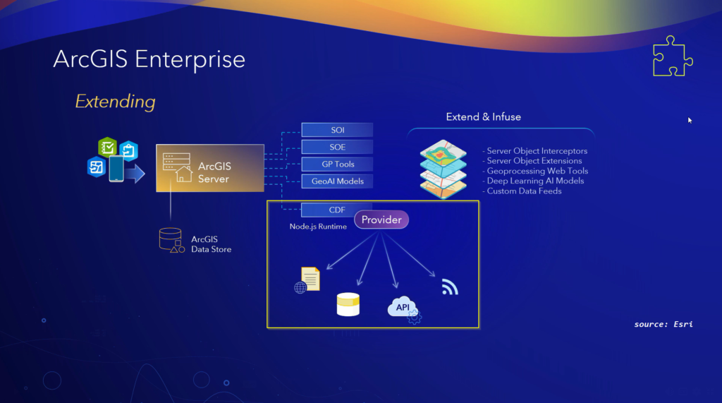
If you are interested in the latest cloud offerings for Enterprise you will be happy to know ArcGIS Enterprise on Kubernetes is ready for the prime time. The message coming through the entire summit is that they have been hard at work at improving ArcGIS Enterprise on Kubernetes and building parity with the existing ArcGIS Enterprise suite of extensions. Through a series of demonstrations, Esri demonstrated just how powerful, capable and robust Enterprise on Kubernetes can be. In addition, raster analytics will soon be available on Kubernetes as well.
Lastly, Esri demonstrated a brand new product offering, called ArcGIS Video Server, a new server role for ArcGIS Enterprise. Video server will allow organizations to index, curate, organize and stream georeferenced video streams, offering seamless and integrative situational awareness.
Mobile Apps
There were a ton of updates to mention that pertain to Esri’s COTS solutions including Field Maps, Survey123, QuickCapture and Workforce. Field Maps has continued to integrate more of the advanced form features and Arcade features that are honored in other parts of the ArcGIS suite. Likewise, Esri demonstrated new advanced capabilities for viewing and tracing features while leveraging the ArcGIS Utility Network. Indoor positioning support has also been enhanced within Field Maps as well.
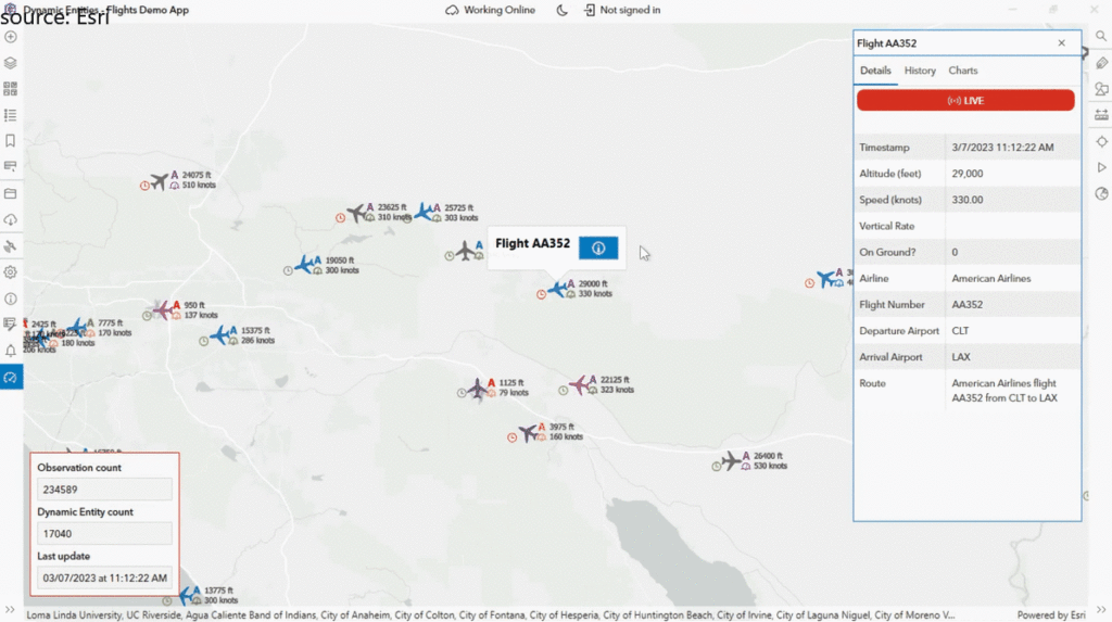
On the custom side, there were too many updates to Esri’s Native Maps SDK’s to mention them all here. However, one of the most exciting new features that will be coming to the native apps is support for real-time data feeds and updates through a feature known as the Dynamic Entities API (available in April 2023).
Web Development
Particularly close to my heart is the web development sphere of the ArcGIS system, and there was a ton to talk about here. State of web development 2023 in two words: web components. In between the world of COTS / no-code solutions and completely custom apps, lies the powerful combination of reusable code and customizable widgets known as web components. Through a series of talks, Esri proved just how much they have invested in this paradigm, the advantages of using web components and showcased their ever-growing library of calcite components and the stellar Calcite Design System that allows developers to get up and running quickly. These components have recently been enhanced with some useful features such as localization, theming, and accessibility.
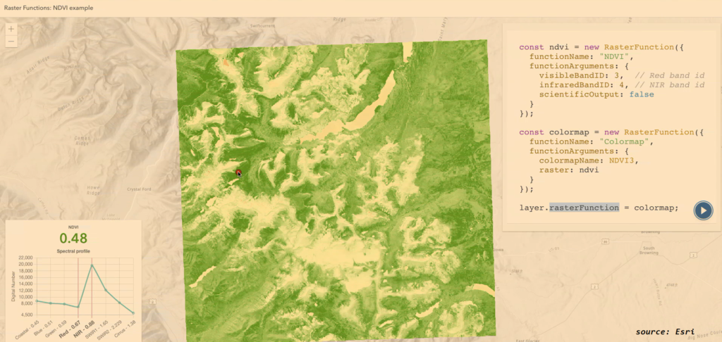
On the custom web front, there is no bigger player than the ArcGIS Javascript SDK, and here too, there were many new features to mention. The latest Javascript SDK powers many of the features within the online Map Viewer, and so the new cluster charting and binning rendering capabilities already mentioned earlier for ArcGIS Online, are available directly in the SDK as well. The JS team has also added to the client-side analytics features by adding raster functions for raster analytics.
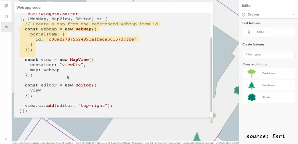
There were also enhancements to the JS editor widget, such as allowing seamless integration of contingent values, Arcade expressions and forms from webmaps/layers directly into the widget as well as improvement to the 3D editing experience.
Game Engines
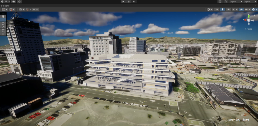
One of the biggest news items from this year’s summit is Esri’s growing footprint in XR (extended reality) for augmented and virtual reality based applications. Extended reality is essentially tech that enhances or changes our view of the real world. Esri has been hard at work with updates to their ArcGIS Maps SDK for Unreal Engine and ArcGIS Maps SDK for Unity and announced great new features such as support for vector tile services and building scene layers directly in the game engines.

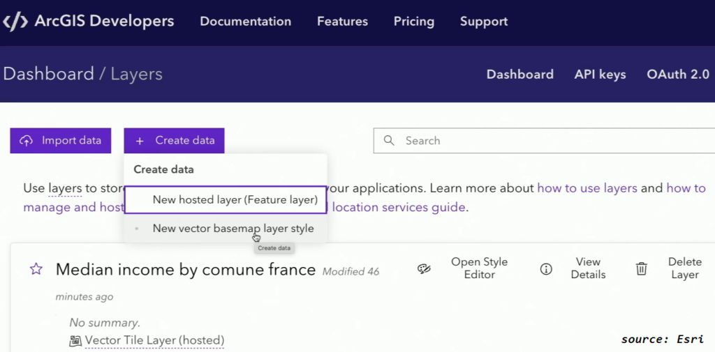
ArcGIS Platform
First off, what is the ArcGIS Platform? ArcGIS Platform is one of Esri’s platform as a service offerings that offers many of the location services, layer services and features from its ArcGIS Online counterpart, but without the entire front end. It is consumption based, and offers a simple and intuitive site for developers and organizations to sign up and leverage existing services, or even host their own data and services. Some of the enhancements coming to the platform, include the ability to allow specific scopes and service types for API keys from the developer dashboard and a new beta feature for setting specific scopes for content items. Esri has made it clear, it is putting developer experience as one of the highest priorities on the platform, as it has never been easier to start utilizing and integrating Esri’s location services directly into your enterprise and external applications.
Plenty more…
This debrief is by no means exhaustive, as there were plenty of other great items demonstrated by the teams over at Esri. To find out more about the Developer Summit and access some of the sessions, check out the Esri Developer Summit page.